 The importance of Lake Okeechobee to South Florida wading bird populations has been recognized since National Audubon Society wardens began patrolling the area during the early 20th century. The earliest aerial surveys were conducted at the Lake from 1957 to 1960, and then again during the early 1970s, as part of regional and statewide efforts to monitor wading birds. Nest counts reached a high point of 10,400 in 1974 during this period in the history of known surveys. In response to concerns about the effect of proposed management increases in lake levels on wading birds, the South Florida Water Management District began in 1977, monthly surveys of nesting birds throughout the breeding season that ran annually until 1992. During this period, the overall presence of breeding wading birds on Lake Okeechobee declined by 60%. There were no other surveys on the Lake until 2005, when Florida Atlantic University (FAU) conducted a single survey at the end of the nesting season. Then in 2006, FAU initiated monthly aerial surveys to determine the size and location of wading bird colonies on Lake Okeechobee as part of the Monitoring and Assessment Plan of the Comprehensive Everglades Restoration Plan.
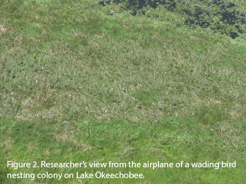
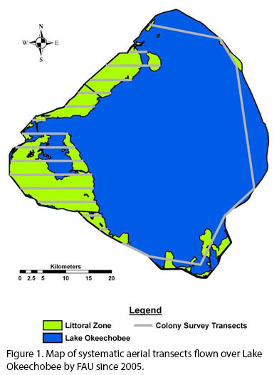
Monthly Colony Surveys - Once a month from January through June, formal aerial surveys are conducted along aerial transects flying at an altitude of 244 m and a speed of 185 km/hr. One transect parallels the eastern rim of the lake from Eagle Bay Island to the Clewiston Lock (Fig. 1). Remaining transects are oriented East-West, spaced at an interval of 3 km and traverse the littoral zone. During surveys, two observers search for groups of large white wading birds, one from each side of a Cessna 182. Once a colony is observed (Fig. 2), we circle it at a lower altitude of 122 m to enable us to estimate the number of nests of each species present within the colony, as well as to record photographs and geographic coordinates of the colony. Ground verification is performed by airboat to improve colony counts and species composition estimates. Colonies are defined post-hoc as any assemblage of > 2 nests that are separated by >200 m and distances between colonies are calculated using ArcGIS.
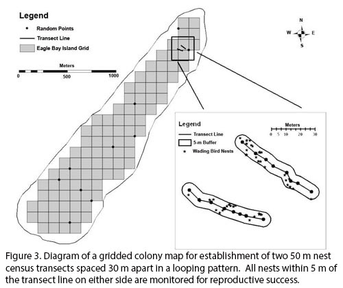
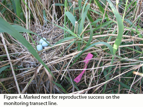
Weekly Productivity - Within three of the largest and most accessible colonies, we establish regular nest census transects and visit them once per week. Transect origins are randomized from gridded colony maps (Fig. 3). We establish two 50 m transects spaced 30 m apart within the colony in a looping pattern. We monitor all nests within 5 m of the transect line on either side for reproductive success. Each new nest attempt along transects is marked with flagging tape and assigned an identification number (Fig. 4). We record the species, nest stage, and nest fate of all monitored nest attempts. All visible nests and attending adults within 5 m of the transect line on either side are recorded to estimate wading bird nest density. Comparisons among aerial surveys, low-altitude photography, and distance-derived density estimates are analyzed for consistency and accuracy.